
What is Topography?
Typography is the best term to define what the landmass in detail. You can show the surface in maps or charts by practicing typography as an art of portraying. Meanwhile, there are subtle and manmade features. It also describes about relative elevations and positions. There is a separate section including the space for writing and describing the typography part of terms. It also represents the surface feature. There is an approximate contours and altitude of a region. Also, with the help of typography, you can see the real features of two-dimensional picture. Multiple people can use typography use for different activities of the sectors like engineers, government workers, hikers, and surveyors can use it. There are different typographical features such as elevations, landforms, longitude, latitude, etc. Experts prefer latitude for south and north poles at the equator. We also use longitude to represent east and west position at the position of Prime meridian. Landforms represent physical features to represent the earth like rivers, mountains, hills, plains, lakes, plateaus, etc. Elevation refers to the height of natural things above from the sea level. In this way of using typography, we will have a necessary information with the exact locations.
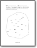
Building a Topographic Map from Benchmarks
Use the benchmark points below to draw contour lines. The contour lines should be drawn at 20 foot intervals.
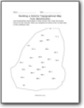
Building a Colorful Topographical Map from Benchmarks
Use the benchmark points below to draw contour lines. Draw the contour lines at 20 foot intervals. When you complete the contour lines, fill each layer in with a different color.

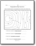
Topographical Map Questions
Answer the questions based on the topographical map. Elevation scale is based on feet. Use the contour lines to determine the elevations of each point on the topographical map. The contour lines are in intervals of 20 feet.

Sightseeing with a Topographical Map
Use the contour lines to determine the elevations of each point on the map. The contour lines are in intervals of 20 feet.